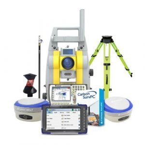
Description
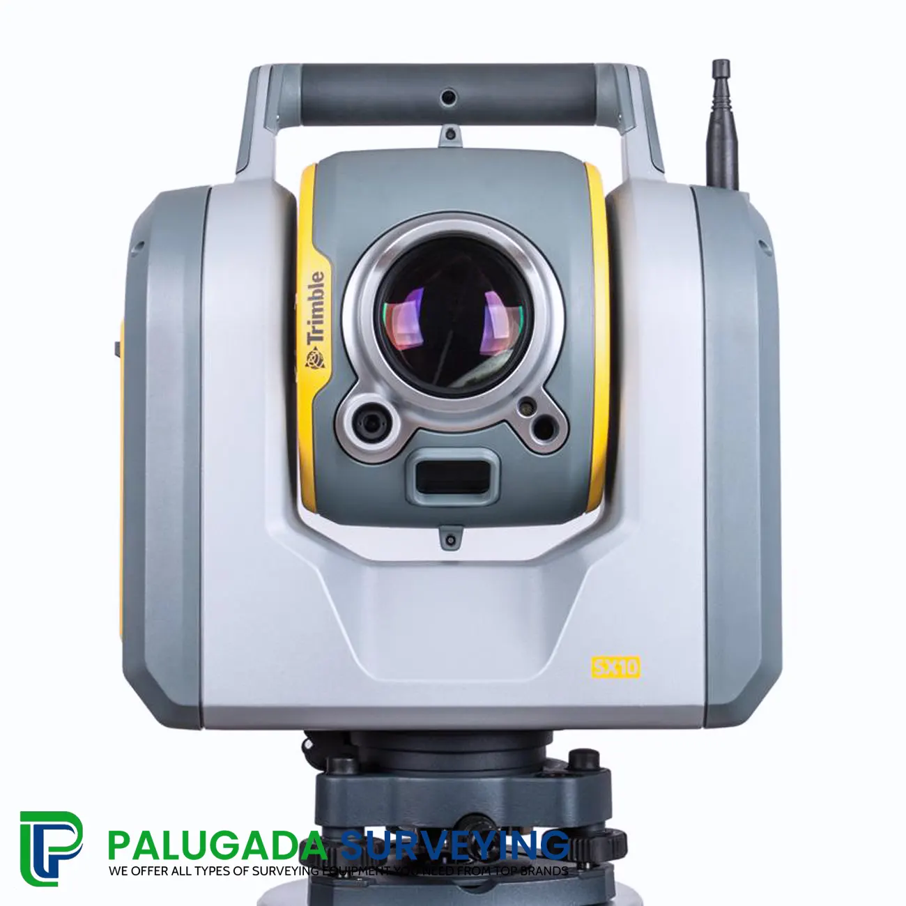
Trimble SX10 3D Scanning Total Station
Trimble SX10 combines three traditional instruments into one! Now you can survey, capture images, and perform high-speed 3D scans with one piece of equipment. Loaded with Trimble’s Lightning 3DM technology the SX10 has scanning ranges up to 600 meters and can capture up to 26,600 points per second.
Combine that with Trimble Vision technology and you now have an instrument that can quickly and easily capture high-resolution images of your site. In addition, you will continue to get to work with Trimble Access and Trimble Business Center software. Both software you are already familiar with and comfortably operate in. The Trimble SX10 will change the way you work!
Trimble also offers the SX10, which brings together the capabilities of a total station with 3D laser scanning. This is great for picking up survey targets and detail in the scene while also scanning, and is one of the leading hybrid products on the market.
Innovative solution for surveying, engineering, and scanning professionals

SX10 Scanning Total Station combines high-speed 3D scanning, enhanced Trimble VISION™ imaging technology, and high-accuracy total channel measurements into the familiar area and workplace workflows for surveyors. The innovative solution supplies surveyors and geospatial professionals together with the capabilities and flexibility to handle projects from regular surveys to complex 3D modeling.
The SX10 3D Scanning Total Station is fresh and pioneering, delivering the world’s most advanced solution for surveying, engineering, and scanning by redefining the abilities of routine survey gear.
The revolutionary SX10 3D Scanning Total Station may collect any arrangement of high-density 3D scan data, higher accuracy total station information, and enhanced Trimble VISION imaging, allowing users the ability to capture what they require, which increases productivity and time.
The SX10 Scanning Total Station includes the new Lightning 3DM, which permits the SX10 Scanning Total Station to capture both higher accuracy total station measurements and accurate high-speed 3D scans collectively — supplying a higher degree of accuracy and measurement performance than previously and all in one single instrument.
The on-board Trimble VISION technology makes it effortless to direct surveys via live video on the controller and provides varying levels of imaging capacities and resolutions, allowing users to collect the correct number of information to fit their requirements, whether that’s documenting the site or capturing additional visual detail in their DR observations. Trimble VISION gives the option of earning extra measurements or delivering 360-degree panoramas if users return to the workplace.
With an unrivaled standard for accuracy, capability, and functionality the SX10 Scanning Total Station always delivers, even on the hardest of survey products.
Features
- Combines surveying, imaging, and high-speed 3D scanning in one revolutionary solution.
- Trimble’s high accuracy Lightning 3DM technology provides a scanning range up to 600 m and the smallest spot size in the industry-a mere 14 mm at 100 m.
- Utilizes Trimble Lightning scanning technology to scan up to 26,600 points per second captures a full-dome scan in as little as 12 minutes.
- Improved Trimble VISION™ technology allows for fast and easy capture of high-resolution site imagery.
- Complete integration with familiar workflows of Trimble Access and Trimble Business Center Software.
Applications
- Topographic Survey/General Surveys (Boundary/Land Title Surveys)
- Roadway/Corridor Surveys (Roadway design and Topo)
- Volumetric Surveys (Stockpile volumes)
- Infrastructure Surveys (Civil Infrastructure As-Builts)
- Building As-Built and Design Surveys
- Utility Design Survey
- Power Line Inspection/Clearance
- Forensics/Crash Scene Investigation
- Mine/Quarry Survey
- Tank Calibration/Inspection
- Dimensional Control
Software
Trimble Business Center lets you completely integrate SX10 data into your projects employing the familiar workflows of the marketing leading survey office computer software. Increased point cloud direction, automatic extraction, and interoperability to leading CAD and GIS packages ensure that you can fulfill even your toughest client requirements.
The Trimble Tablet Rugged PC operates the feature-rich, intuitive Trimble accessibility area software. Streamlined workflows guide crews through common project types, helping to get the job done quickly without distractions. Trimble Access workflows may also be customized to satisfy your needs.
How Does Trimble SX10 Work?
The SX10 measures dense 3D scan data at up to 26,600 points per minute with higher precision over the full measurement assortment of up to 600 meters.
With the SX10, point cloud information is recorded and then automatically registered with your poll workflow. Whether you are capturing complete gamut scans from your station installation or just augmenting your survey data with scans of certain regions of interest, all the information will drop right into your poll coordinate system.
Using Trimble VISION technologies onboard the SX10, you’ve got more energy to direct your survey with live video pictures on the control, and you can make a vast array of deliverables from gathered imagery.
The SX10 delivers a higher level of performance, including the ability to capture complete ribbon panoramas in as few as three minutes. Additionally, it provides varying degrees of imaging capacities and resolutions, whether you are documenting your site or capturing additional visual detail onto your DR observations.
Back at the office, Trimble Business Center enables you to completely incorporate Trimble SX10 data into your endeavors using the familiar workflows of all market-leading survey office computer software. Enhanced point cloud management, automated extraction, and interoperability to leading CAD and GIS packages to ensure you can satisfy even your toughest customer requirements.
Reference Library
- Manufacturer Information
- Brochure