Description
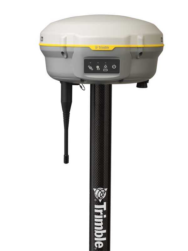
Trimble R8s Integrated GNSS System
Trimble R8s GNSS receiver gives you just the features and benefits you need, in one flexible, scalable system so you can build a system tailored to your job. As your requirements change, the R8s can adapt. Simply add functionality whenever you need it. With Intuitive Access Field Software and Trimble Business Center Office Software and Trimble DL Android app for collecting static GNSS raw data for post-processing.
Backed by a legacy of GNSS technology and surveying expertise, Trimble provides surveyors with reliable GNSS survey solutions that meet their distinct requirements. Whether you need the cable-free convenience provided by Trimble integrated systems, the flexibility of modular systems, or the simplicity of handheld point measurement, Trimble has a solution for you.
Configured for today scalable for tomorrow, the R8s GNSS receiver is a flexible, scalable system that offers all of the features and benefits you expect, in one customizable system.
Trimble R8s Features & Benefits:
- One configurable receiver that is scalable for future needs
- Available in post-processing, base only, rover only, or base & rover configurations
- Advanced satellite tracking with Trimble 360 receiver technology
- Includes Maxwell 6 chips with 440 channels
- Simple integration with S-Series Total Stations and the V10 Imaging Rover
- Intuitive Trimble Access Field Software and Trimble Business Center Office Software
- Communication options and remote access via web UI
- Free mobile app – a new way to quickly collect GNSS raw data
Superior GNSS Technology at an Affordable Price
 The Trimble R8s GNSS receiver gives you the features and benefits you need, in one flexible, scalable system. Just choose the configuration level which fits your needs best, whether it’s post-processing, foundation, rover, or a combination of base and rover functionality.
The R8s give the ultimate in scalability. Only choose the configuration level that fits your needs best, whether it’s post-processing, base, rover, or a combination of foundation – and – rover functionality. When you have selected a configuration degree, additional individual choices could be added to extend the receiver functionality further.
Together with powerful TSC3 control, Access field software, and Trimble Business Centre (TBC) office applications, the R8s GNSS process is a complete field-to-finish questionnaire solution that will meet your requirements.
Rather than a pre‑configured system, the R8s GNSS system gives you just the features and benefits you need, in one flexible, scalable system. It’s never been easier to create a system tailored to your job.
The R8s readily integrates with Trimble S-Series total stations and the advanced V10 imaging rover. Produce a complete solution by combining the R8s receiver with a Trimble controller running Trimble Access™ area software, and Trimble Business Center office software.
With the R8s, it’s easy and simple to build a receiver that is right for the job. Choose the configuration level that suits your needs best, whether it’s post-processing, base, rover, or a combination of base and rover functionality. After you’ve selected a configuration level, additional individual options can be added to further extend the receiver functionality.
Trimble Mobile App—-A New Way to Quickly Collect GNSS Raw Data
 The Trimble DL Android app gives a very simple and user-friendly mobile interface for collecting static GNSS raw data for post-processing functions without the need of utilizing a Trimble controller or Trimble Access area computer software. This free of cost program can be found via the Google Play Store and operates on Android smartphones and tablets
The new Trimble Penmap for Android is a cloud-connected program for field surveying and high-accuracy GIS information collection. It functions on mobile handhelds, tablets, and smartphones.
The program runs on a variety of Android devices, for instance, rugged TDC100 handheld, and supports full-featured Trimble GNSS receivers such as the R10, R8s, and R2 recipients.
Leading technology
- Each R8s comes integrated with powerful Trimble 360 tracking technology that enables you to expand the reach of your GNSS rover to sites that were previously inaccessible.
- Two integrated Maxwell 6 chips and 440 GNSS channels.
- Eliminate the need to travel for routine monitoring of base station receivers with Trimble’s exclusive Web UI.
- Trimble DL Android app provides a straightforward mobile interface for collecting static GNSS raw data for post-processing without the need to use a Trimble controller or Trimble Access software.
The complete solution
- Easily integrates with Trimble S-Series Total Stations.
- Create a complete solution by combining the Trimble R8s receiver with a Trimble controller running Trimble Access™ field software, and Trimble Business Center office software for checking, processing, and adjusting your data.
What’s Included:
- R8s Accessory – Transport Case (Single or Double Receiver)
- Accessory – Battery – Lead Gel Charging Kit, Outside with Pouch, 6Ah, 0S/7P/M Cable
- R8S UHF Rover/Base Receiver
- 2X Receiver Batteries
- Dual Hard Carry Case
- UHF Antenna
- Dual Bay Battery Charger
- Rover Carbon Fiber 2M Rod
- BiPod
- R8/ R8s Li-Ion Rechargeable Battery 7.4V, 2800 mAHr
- R8s- UHF Radio Antenna (Survey)
- Antenna Module Connection Cable Set Replacement for R8s
- TPP Firmware Warranty Good Until 01/06/2023
Reference Library
- Manufacturer Information
- Brochure
FEATURES
- One configurable receiver, scalable for future needs
- Advanced tracking with Trimble 360 technology
- Includes Trimble Maxwell 6 chip with 440 channels
- Intuitive Trimble Access field software
- Trimble Business Centre office software
- Available in post-processing, base only, rover only, or base & rover configurations
- Simple integration with Trimble S-Series Total Stations
- Trimble DL Android app for collecting static GNSS raw data for post-processing


