Description
Trimble R2 Integrated GNSS System, a durable GNSS receiver to collect highly accurate, provides total flexibility based on the accuracy and GNSS performance level
 The Trimble R2 is a rugged, durable GNSS receiver that offers an easy-to-use alternative to GIS and survey professionals who need to collect highly accurate data in much different precision survey software.
Capable of providing between submeter and centimeter positioning precision in real-time to some mobile device via a wireless Bluetooth® relationship, the R2 receiver offers you total flexibility to choose a solution based on the accuracy and GNSS performance level that works for your program, letting you work how you want.
Collected data can then be processed using Trimble office software, such as the Trimble Business Center or TerraFlex, supplying you with high-quality deliverables to your organization.
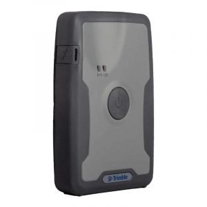
Trimble R2 GNSS Receiver for Mobile Devices
 The Trimble R2 GNSS receiver is compact and portable weighing only 2.4 pounds. With one button operation and area swappable battery, the receiver can be pole or vehicle mounted or carried on a backpack. The R2 is a multi-constellation receiver that supports GPS, GLONASS, Galileo, BeiDou and QZSS satellite signals in addition to Satellite Based Augmentation Systems (SBAS). With a variety of optional and standard correction capabilities, the Trimble R2 can achieve sub-meter into centimeter placement for a broad range of precision demands. Also, the GNSS receiver is an ideal selection for organizations who have adopted a workplace Bring Your Device (BYOD) strategy. Its setup and ease-of-use raise time-to-job conclusion and data collection productivity to allow users to work more efficiently.
Workflows — GIS and Survey Field Program
Designed for the two GIS field data collection and survey workflows, the Trimble R2 receiver integrates with Trimble TerraFlex™ mapping and GIS field applications and Trimble accessibility ™ survey field software.
 TerraFlex software is a scalable cloud-based solution for geospatial data collection. By pairing the R2 using a smart device or Trimble handheld running TerraFlex, the solution covers a huge variety of field requirements such as attribute-rich GIS information collection on professional and consumer devices. With an intuitive interface and compact toolset for creating custom electronic form templates, TerraFlex retains the data flow standardized and compact from the area to the workplace.
Trimble Access applications support the workflows of regular surveying tasks such as topographic and control surveys and technical surveying tasks such as roads, tracking, mines, and tunnels. By pairing the receiver using a Trimble handheld running Trimble Access or TerraFlex field software, the Trimble R2 is a versatile option that supports the full selection of geospatial data collection workflows for both GIS and surveys software.
Adaptive Truth
Capable of receiving a wide range of corrections from traditional RTK, VRS networks, and SBAS to Trimble RTX™ correction solutions via cellular/IP connections or satellite (L-band), the Trimble R2 provides high-accuracy data globally.
The R2 GNSS receiver may leverage the entire portfolio of subscription-based Trimble RTX correction services to accommodate a wide selection of applications and precision requirements.
The Way It Works
The Trimble R2 may mount on a rod, on a backpack or a motor vehicle. The Trimble R2 provides GNSS positions in real time. Correction sources such as SBAS, VRS or RTX networks may be applied to provide the most reliable GNSS data globally. The Trimble R2 integrates with the flexible workflows of all Trimble applications such as Trimble Access™, Trimble TerraFlex™ and Trimble Business Center to enable information to be easily collected, processed and conveyed, Offering You high-quality deliverables to your company
Trimble R2 Integrated GNSS System Manufacturer Information
FEATURES
- Easily collect data by pairing with devices such as smartphones, tablets or Trimble handhelds
- One-button startup and compact, streamlined design enables a quick setup.
- Flexibility to choose your data collection device.
- Built to withstand tough conditions meeting military specifications MIL-810G for ruggedness and an IP65 rating.
- Fast to setup, easy-to-use, keeping you productive and focused on your work.
- Supports multiple satellite constellations and correction sources for accurate data at any location.
- Trimble Maxwell 6 chip with 220 channels and leading GNSS technology maximizes data quality
- A professional solution for geospatial applications ranging from sub-meter to centimeter accuracies
VIDEO
DOWNLOAD
Trimble-r2-datasheet