Description
Trimble R10 Model 2 GNSS System, Advanced GNSS Rover System
Collect More Data Faster and Easier with greater quality control

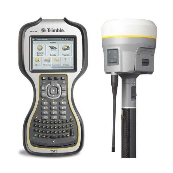
Trimble R10 GNSS System is designed to help you operate more effectively, no matter how intense the environment. The new, lighter layout is more balanced, allowing you to travel further, faster, and gather information more easily.
Combined with Trimble accessibility and the TSC3, the Trimble R10 is the most effective solution on the market today, representing a new age in GNSS surveying.
Built-in firmware gives automatic reimbursement for up to 15 degrees of pole tilt and RTK level accuracy everywhere! Constructed with powerful technologies like Trimble HD-GNSS, Trimble SurePoint? , Trimble CenterPoint? RTX, and Trimble xFill? , incorporated into a slick design, this unique system provides Surveyors with an effective way to increase productivity in every job, every day.
The Trimble R10 GNSS system, with all the Trimble Access field applications and the Trimble Business Center office applications, supplies the most advanced GNSS surveying system on the industry.
Collect more accurate data faster and simpler – no matter what the task or the surroundings, together with the Trimble® R10 GNSS System.
Trimble R10 Key Benefits
- Reach formerly inaccessible points: get the tip of the survey pole into tight corners and other things which are inaccessible using a vertical survey rod
- Quicker Accreditation: Less time per point Is Needed to collect information because the pole doesn’t need to be precisely 90 degrees and the 100 percent dimension accuracy report guarantees confidence
- Safer for your own surveyor: listen to local traffic or heavy machines instead of having to concentrate on holding the rod plumb
How Trimble R10 Works
 As the smallest and lightest integrated receiver in its class, the Trimble R10 is designed for effortless performance. The progressive design comprises a more stable center of mass at the peak of the range rod, although its sleeker, taller profile provides the durability and reliability for which Trimble is known.
The Trimble R10 receiver incorporates a quick-release adaptor for easy and safe removal of the receiver from the stove pole. The adaptor also ensures a solid, stable connection between the receiver and the range pole.
Using Trimble SurePoint, pole tilt is constantly monitored by the system and compensates while the point is manually or automatically measured.
Include:
- Trimble R10 L1/L2/L2C/L5/GLONASS/Galileo/BeiDou/QZSS xFill receiver
Firmware 5.48
GLONASS Enabled
BeiDou Enabled
Galileo Enabled
QZSS Enabled
xFill Enabled
Trimble SurePoint enabled (tilt sensors)
403-473MHz internal radio
Quick-release adapter
Trimble whip antenna
2 R10 batteries (1 new generic, 1 used Trimble)
- New Trimble TSC7 Data Collector w/Trimble hardware warranty until 11/2/2022
Windows 10 Pro
7″ touchscreen
8GB RAM
64GB internal memory
Blue Tooth
WiFi
Cellular
Built-in GPS
Microsoft Office
Trimble Access version 2020.11 with Trimble support until 11/8/2021
2 new Trimble batteries
New stylus with lanyard
New Trimble battery charger/power supply
New Trimble soft carry pouch
New Seco pole clamp
- Accessories:
New Trimble 32659 DB9 to Lemo 7 data cable
Trimble dual-port battery charger with power supply
Trimble hard case
Trimble R10 GNSS System
A new model of the Trimble® R10 GNSS system is now available. Designed to help surveyors in a wide range of industries work more effectively and productively, the Trimble R10 GNSS receiver enables reliable, fast, and accurate collection of survey data in the field.
The Trimble R10 enhancements include:
- The latest and most advanced custom Trimble survey GNSS ASIC with an industry-leading 672 GNSS channels for unrivaled GNSS constellation tracking, including GPS, GLONASS, BeiDou, Galileo, QZSS, IRNSS as well as the full range of SBAS. The Trimble R10 tracks and processes all of today’s available GNSS signals and is designed to support planned GNSS signals and systems that may be launched in the future.
- Improved reliability against sources of interference and spoofed signals.
- Improved power management to increase battery life and operating time in the field on average by 33 percent.
- Increased internal memory (6 GB) to store more than 10 years of raw observations.
- Support for Android and iOS platforms to allow organizations with Bring Your Own Device (BYOD) environments to benefit from a premium survey GNSS receiver by using the mobile devices their field crews already have in their pockets.
The new features build on the Trimble R10’s core technologies:
- Trimble HD-GNSS processing engine that enables points to be quickly measured with confidence
- Trimble SurePoint™ technology for precise positioning capture and full tilt compensation
- Trimble xFill® technology for centimeter-level positioning during outages
- Support for Trimble CenterPoint® RTX corrections for RTK level precision worldwide
Trimble R10 Model 2 GNSS System Library
Trimble R10 Model 2 BROCHURE
Trimble R10 Model 2 GNSS System Manufacturer Information
FEATURES
- Trimble xFill™ provides less downtime in the field, with continuous RTK coverage during connection outages from an RTK base station or VRS network
- Trimble CenterPoint™ RTX™ delivers GNSS corrections via satellite or internet connection anywhere in the world for unprecedented speed and accuracy for a PPP solution.
- Cutting edge Trimble HD-GNSS processing engine enables surveyors to measure points more quickly.
- Trimble SurePoint™ fully compensates for pole tilt. Conveniently measure points that were otherwise inaccessible with complete quality assurance.
- Powerful 440-channel solution with Trimble 360 technology delivers the most advanced satellite tracking.
- Ergonomic design for easier and more comfortable handling.
- Integrates seamlessly with V10 Imaging Rover and S-Series total station positioning sensors.
- Pair with Trimble Access and the TSC3 controller, Trimble Tablet, Slate or Trimble CU for the most powerful solution on the market.
VIDEO
DOWNLOAD
Trimble R10 Datasheet


