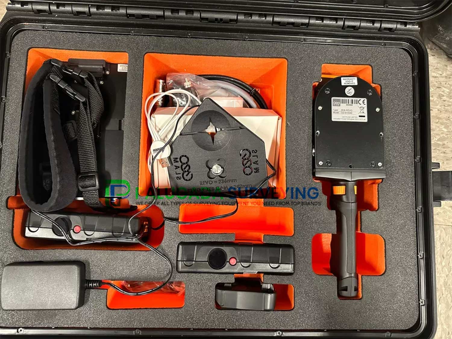
Description
GeoSlam ZEB Revo RT Real-Time Handheld Scanner, Go-anywhere 3D mobile mapping technology. Handheld, lightweight and easy to use, the ZEB REVO RT allows you to rapidly build highly accurate 3D models within minutes, while on the move.
Includes;
- (1X) ZEB REVO RT 3D Laser Scanner
- (1X) ZEB REVO RT Processing Unit
- (1X) Main Cable
- (2X) Batteries
- (1X) Battery Charger
- (1X) Shoulder Strap
- (1X) ZEB-CAM Cable
- (1X) Heavy Duty Carry Case
- (1X) Magnetic Mount
- (1X) Reference Base
GeoSlam ZEB REVO RT Handheld Laser Scanner
The brand new real-time solution from the experts in “go-anywhere” 3D mobile mapping technology. A handheld, lightweight and easy to use laser scanner that allow you to rapidly collect and process scan data, simultaneously whilst on the move.
“Go-anywhere” 3D mobile mapping technology
Scan, process and track your progress as you go.
Handheld, lightweight and easy to use, the ZEB REVO RT allows you to rapidly build highly accurate 3D models within minutes, while on the move.
The complete solution that allows you to start mapping the world around you today with any WiFi enabled device.
Scan, visualise and process simultaneously, as you walk.
Real-time data capture
Handheld, lightweight and easy to use, the ZEB Revo RT laser scanner allows you to rapidly build highly accurate 3D models within minutes, while on the move.
Speed
With 43,000 scanner points per second, it’s fast work scanning both simple and complex environments. You can carry out high-quality scans in less time.
REAL-TIME
Gain real-time insight into your scan, see the areas you’ve covered (or missed) and the route you’ve taken before you leave site.
ACCURACY
The ZEB Revo RT provides 3D scanning with a survey grade relative accuracy of up to 6mm dependant on the environment. This gives you accurate scans and fine details.
PORTABILITY
Light weight and portable, you can move freely whilst using this device. This portable 3D scanner features a rotating LiDAR sensor for the widest field of view. Its compact size and ergonomic design make it a delight to use.
THE NEW FEATURES:
> Visual inspection of the scanned area directly during measurement
> Calculation of the cloud of points through the GeoSLAM algorithm in real time
> Cloud coloring with ZEB-CAM
> Easily manage and connect point clouds in GeoSLAM Hub
> Generating sections and vector models in the GeoSLAM Draw environment.
THE FEATURES:
> Model Geoslam ZEB-REVO RT
> Maximum range 30 m ( in enclosed spaces ), 15-20 m ( in open spaces )
> Scan speed 43,200 points / s
> Resolution 0.625 ° horizontally, 1.8 ° vertically
> Measurement accuracy 2 – 3 cm 1 – 3 cm
> Overall measurement accuracy 3 – 30 cm ( 10 min scanning and forming a closed loop )
> Field of view 270 ° x 360 °
> Hard disk capacity 55 GB 120 GB
> Default LAS, PLY and E57 recording format
> Supply voltage 12 V DC ± 10% 14.8 V
> Power current Max. 15 A, norm. 1.0 A Max. 10 A, norm. 2.5 A
> Energy consumption Less than 20 W 30 W
> Operating temperature from 0o to + 50 oC from + 10 ° to + 30 ° C
> Maximum humidity 85% RH
> Method of attachment to the holder, telescopic boom, backpack, vehicle
> Sensor Laser safety class Class 1 ( eye safe )
> Sensor Laser beam length 905 nm
> Sensor Scan frequency 100 Hz
> Battery type Lithium-Polymer ( Lipo ) Li-Ion
> Operating time 4 hours in continuous operation 1.5 hours in continuous operation
> Charging time 8 – 12 hours
> Service life 300 + charging cycles
> Standard IP IP64 IP51
> LEMO multi pin cable connectors
> System / scanner weight 4.1 kg / 1.0 kg 6.3 kg / 1.0 kg
> Scanner dimensions 86 x 113 x 287 mm 220 x 180 x 470 mm
> Backpack dimensions 220 x 180 x 470 mm 460 x 370 x 180 mm
> Software GeoSLAM Hub software
THE SOFTWARE:
> The color of the point cloud using an image obtained from the ZEB-CAM camera
> Fast creation of cross-sections, projections and heights from a point cloud and their vectorization ( transformation to lines ) using the GeoSLAM Draw module
> Monitoring scans and adding annotations using the GeoSLAM View module
> Fast and accurate scan connections to collect all results into one coordinate system
The price of the equipment also includes the program GeoSLAM Draw, which is an excellent tool for generating vector drawing, cuts, views, calculating cubatures, etc. Interesting function Vectorized in the cloud of points, it automatically recognizes edges and lines and interprets a line drawing in them. This can then be loaded into the CAD system in the format DXF.
GeoSLAM HUB SOFTWARE:
> Transform your scan data into actionable intelligence using GeoSLAM Hub
> Industry-leading SLAM processing to generate accurate 3D point clouds from mobile data
> Automatic registration of multiple scans and geo-referencing of datasets to control
> Import, view and interrogate data captured from all GeoSLAM mobile mapping devices
> Generate simple and fast 3D measurements and 2D CAD deliverables
> Easily export data for use with all major third-party CAD and GIS software packages