Description
GeoSLAM ZEB HORIZON LiDAR scanner, suitable for drone mapping applications as well as indoor use.
This powerful tool helps make the mapping process simple. With a range of 100m, the ZEB Horizon is great for outdoor use including spaces where features are positioned further apart.
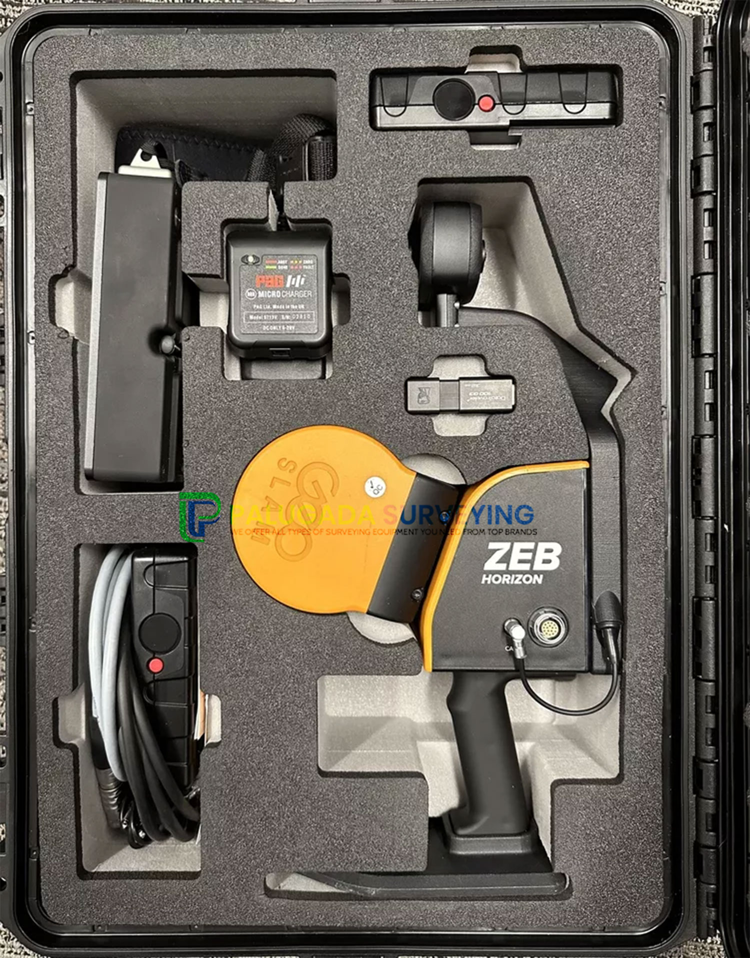
Includes:
- ZEB Horizon Scanner
- ZEB Horizon data logger with shoulder strap (incl. 14.8V battery)
- 14.8V Battery Charger
- ZEB Horizon main cable (1.5m length)
- USB memory stick
- Reference base
- Shipped in a soft carry case
- GeoSLAM Connect software (Not Included with Open Box Products)
- 3-year hardware warranty when a valid GeoSLAM Care package is in place
Specifications and Features
Its lightweight and compact design also make it perfect for indoor surveys. If you want flexibility in your data capture methods, the ZEB Horizon is the solution for you. Here’s the low-down on the ZEB Horizon:
Create a map as you move. Outdoors, indoors or underground. It’s lightweight and compact design makes it simple whether you’re new to digital mapping, or a trained surveyor. With powerful SLAM technology at its heart (we call it GeoSLAM Beam), the ZEB Horizon can be used in areas with poor GPS – such as underground or in forests. Lightweight and rugged, simple to use, fast to capture and easy to process giving you the most accurate information you need to make the most important decisions.
The ZEB Horizon is as flexible as you are. Use handheld or pair with one of our many mounting options. Take your ZEB to the skies by mounting to a UAV or reach those difficult places with the cradle or pole.
Effortless Data Capture
With a range of 100m, the ZEB Horizon is great for outdoor use including spaces where features are positioned further apart. It’s lightweight and compact design also make it perfect for indoor surveys. ZEB Horizon is your tool to capture, process and understand the world around you.
Survey Grade Point Cloud In Minutes
With one button operation, you’ll be up and running fast – capturing survey grade data in minutes. Process a point cloud quickly using the intelligent point cloud processing platform GeoSLAM Connect. GeoSLAM data is compatible with software that works for you with universal file formats (LAZ/LAS/PLY/TXT/e57).